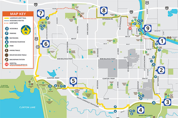

This map should help trail users identify sections of the Lawrence Loop best suited to their interests and abilities. Trail lengths are approximate. To ensure your safety, we recommend using the Loop with a friend, carrying water, and being constantly aware of your surroundings. Be particularly careful when navigating street crossings.
Blue dots identify the most accessible sections because of factors like easy access to parking and trail slopes. The orange dashes can be used to navigate gaps in the Lawrence Loop.

Santa Fe Station/Hobbs Park
Length: 0.5 mile
Parking: Warehouse District, Hobbs Park
Restrooms: Hobbs Park
The Lawrence Loop begins at the Santa Fe Station and travels southwest towards 8th and Delaware. It continues along Delaware until entering Hobbs Park. After crossing through the park, it turns east on 11th until reaching the Burroughs Creek trail (after crossing 11th Street).

Burroughs Creek and Haskell Rail Trail
Length: 1.75 miles
Parking: Barker Avenue, Burroughs Creek Park
Restrooms: Burroughs Creek Park (seasonal)
The Burroughs Creek and Haskell Rail Trails run from 11th Street to 29th Street on the eastern edge of Haskell Indian Nations University.

Haskell Avenue Connection
Length: 1 mile
Parking: None
Restrooms: None
This section connects the Haskell Rail Trail to the South Lawrence Trafficway.

South Lawrence trafficway (Haskell to Iowa)*
Length: 4 miles
Parking: Baker Wetlands Discovery Center, Broken Arrow Park
Restrooms: At parking facilities
This segment passes along the Baker Wetlands and K-10 to Iowa Street. Exercise caution when crossing Iowa.

South Lawrence trafficway (Iowa street to Arboretum)*
Length: 4 miles
Parking: Southwind theater, Pat Dawson Billings Nature Area
Restrooms: None
The trail runs along Yankee Creek and turns north to run along Kasold Drive (near Kasold on the curve) before turning west until it reaches the Wakarusa/27th/K-10 intersection. Exercise caution crossing the highway towards the Arboretum. This is one of the hillier sections of the Loop.

South Lawrence trafficway (Arboretum to Rock Chalk Park)
Length: 4.5 miles
Parking: Lawrence Arboretum, Rock Chalk Park
Restrooms: Lawrence Arboretum (seasonal), Sports Pavilion at Rock Chalk Park
The trail goes west to Clinton Lake through a meadow. The trail turns north and crosses Clinton Parkway. Shortly after passing under K-10, the trail takes a left turn and heads north towards Rock Chalk Park.

Rock Chalk Park and Baldwin Creek
Length: 2 miles
Parking: Rock Chalk Park
Restrooms: Sports Pavilion at Rock Chalk Park
The Loop crosses Renaissance Drive in front of LMH West before descending into the valley along Baldwin Creek. It ends at trail road. There is a gradual but steady climb back to Rock Chalk Park for those who use the trail from Queens Road up to Rock Chalk Park

North Kasold to Michigan St
Length: 2.5 miles
Parking: None
Restrooms: None
Disconnected from the rest of the Loop, the trail goes from south of I-70 on Kasold and along Peterson Road to Peterson Park. The trail goes through the Park, across North Iowa, and passes through a tunnel under the Turnpike to North Michigan Street.

Sandra Shaw Park to Burcham Park*
Length: 1mile
Parking: Burcham Park
Restrooms: Burcham Park (seasonal)
Disconnected from the rest of the Loop, this section goes through Sandra Shaw Community Health Park, and then into Burcham Park following the river toward downtown Lawrence.
Exercise caution when crossing the active railroad tracks on either end of Burcham Park. The intersection between Burcham and Constant Parks near downtown is an unsignalized crossing.