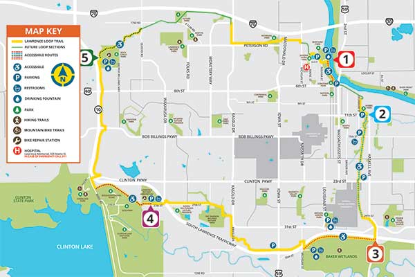
Suggested Accessible Routes
This map highlights sections with more modest slopes that may be best suited to those using a wheelchair or other assistive device and trail users who generally wish to avoid more challenging or hilly terrain. Also included is information about parking, nearby public transit stops, and accessible amenities along the routes. Please note that, in addition to “fixed route” public transit, Lawrence Transit offers the T-Lift, “curb to curb” service with a wheelchair lift or ramp and audio announcement equipment, for eligible riders. More information is available at lawrencetransit.org/ada-services
Sections have been rated as easy, moderate, or hard based on physical observations of the terrain.
Navigating across current gaps:
Several sections of the Lawrence Loop remain incomplete. If you wish to walk, ride or wheel the entire Loop visit lawrenceks.org/loop for details in negotiating these gaps.
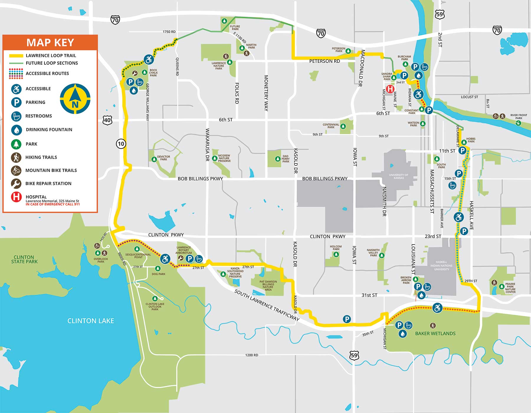
 Burcham Park Route
Difficulty: Easy / Length: .5 miles one way
Parking: Lot at Burcham Park (accessible)
Public transit access: not easily accessible by fixed-route busses. Lawrence Transit Stop 141 (Routes 3 and 6 westbound) can be used to access the trail from Constant Park (to do so means crossing an active, unsignalized rail crossing between Constant and Burcham Parks so please exercise caution).
Restrooms: Burcham Park (seasonal)
Water Fountain: Burcham Park (seasonal)
Benches: Several along the trail
This flat and scenic section of the Lawrence Loop runs alongside the Kansas River and has views of downtown Lawrence. This wooded trail runs a half-mile along the river before it comes to an end at an unsignalized rail crossing. It is possible to cross the tracks to enter Constant Park and access downtown.
 Burroughs Creek and Haskell Route
Difficulty: Moderate / Length: 1.75 miles one way
Parking: (1) Lot east of Barker Avenue/north of 23rd St. (accessible); (2) Lot at Burroughs Creek Park off of 15th. St. The parking lot has recently been made accessible.
Public transit access: Stops 360 and 361 (Transit Route 1) on Haskell Avenue provide great access to the Loop. There is a short sidewalk going west from Stop 361 that connects to the Burroughs Creek Trail (go left, or south, when you get to the trail from the sidewalk)
Restrooms: Burroughs Creek Park (accessible; seasonal)
Water Fountain: Several along the trail
Benches: Several along the trail
The Burroughs Creek and Haskell Rail Trails on Lawrence’s east side run from 11th Street to 29th Street. While most of the trail is quite flat, it was rated “moderate” because of numerous street crossings from 11th to 23rd Street, some with steep curb ramp transitions. The Haskell Rail Trail section is well-shaded and avoids a large number of street crossings, but lacks amenities like water fountains or benches.
 South Lawrence Trafficway Route (from Baker Wetlands)
Difficulty: Moderate / Length: 2 miles one way
Parking: (1) Lot at Baker Wetlands Discovery Center (accessible); (2) Lots in Broken Arrow Park (accessible)
Public transit access: Not easily accessible by fixed-route busses
Restrooms: (1) Baker Wetlands Discovery Center (accessible); (2) Broken Arrow Park (accessible)
Water Fountain: (1) Baker Wetlands Discovery Center (2) Broken Arrow Park
Benches: None
This segment provides excellent views of the Baker Wetlands all along its length from Michigan Street to Haskell Avenue. Users of this trail will encounter little to no vehicular traffic. This segment was rated “moderate” because of some gentle, short, up-and-down slopes, but changes in elevation are modest.
 South Lawrence Trafficway Route (from the Lawrence Arboretum)
Difficulty: easy / Length: 1.5 miles one way
Parking: Lot at Lawrence Arboretum (accessible)
Public transit access: not easily accessible by fixed-route busses
Restrooms: Lawrence Arboretum (accessible; seasonal)
Water Fountain: At the Arboretum (seasonal), none along trail
Benches: Limited number
The Lawrence Arboretum, adjacent to the Youth Sports Complex, provides ideal trail access. The trail west from the Arboretum takes trail users through a meadow with bluffs to the north. After 1.5 miles the trail branches. Trail users can stay on the Loop and go northward (at which point the trail begins climbing), or can cross over the road towards the base of Sanders Mound overlooking Clinton Lake.
 Rock Chalk Park and Baldwin Creek Route
Difficulty level: hard / Length: 2 miles one way
Parking: Lot at Rock Chalk Park (accessible)
Public transit access: Route 6 stop 84 (near Sports Pavilion Lawrence) and Route 6 stop 95 (near LMH Health West campus) are near the western end of this trail section that starts just off of Rock Chalk Park Lane
Restrooms: Sports Pavilion at Rock Chalk Park (during business hours)
Water Fountain: Sports Pavilion at Rock Chalk Park (during business hours)
Benches: Limited
The Rock Chalk Park and Baldwin Creek trail sections take trail users into a scenic valley with views of woodlands, meadows, and in some sections, bluffs along the creek. The trail descends into the valley and then levels out until it ends at Queens Road. The last mile of the return route features a steady climb with some short steep (10%+ grade) sections, so this section was rated “Hard.”
The Lawrence Loop, when completed, will be a paved trail about 22 miles long circling the city, providing opportunities for recreation and access to many key Lawrence destinations. As of January 2022, over 18 miles of the Loop are completed and in use.
The Lawrence Loop and other area trails enable people of all abilities to be physically active and experience the community from many different vantage points. For more information on Lawrence area trails, visit the following websites:
explorelawrence.com/things-to-do/outdoors-recreation/hiking-and-trails
alltrails.com/us/kansas/lawrence
getoutdoorskansas.org/trails (statewide)