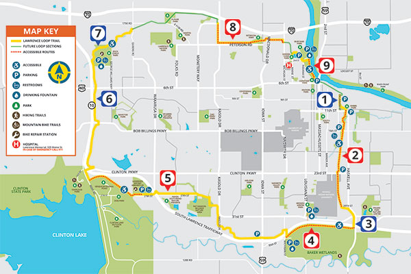
These descriptions were developed to help trail users enjoy their experience on the Lawrence Loop by identifying sections of the Loop that will suit their interests and abilities. Trail lengths are approximate.
Red dots on the map identify the most accessible sections because of factors like easy access to parking and trail slopes.
To ensure your safety on the Lawrence Loop (or any trail) we recommend you use the trail with a friend, be aware of your surroundings, carry water, and exercise judgement when navigating the terrain.
Keep it safe, share the trail, and most of all, enjoy the Loop!

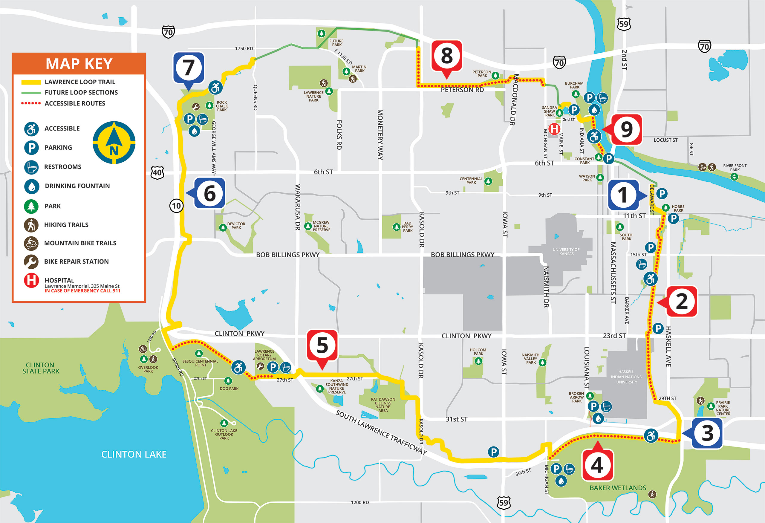
Hobbs Park
Length: 0.25 mile
Parking: Warehouse District, Hobbs Park
Restrooms: Hobbs Park
The Lawrence Loop begins at 8th and Delaware (although there is no signage noting this). Travel south by the Warehouse Arts District to Hobbs Park. The Loop turns east on 11th Street and continues on to the Burroughs Creek Trail.

Burroughs Creek and Haskell Rail Trail
Length: 1.75 miles
Parking: Barker Avenue, Burroughs Creek Park
Restrooms: Burroughs Creek Park (seasonal)
The Burroughs Creek and Haskell Rail Trails run from 11th Street to 29th Street on the eastern edge of Haskell Indian Nations University.

Haskell Avenue Connection
Length: 1 mile
Parking: None
Restrooms: None
This section connects the Haskell Rail Trail to the South Lawrence Trafficway.

South Lawrence trafficway (Haskell to Iowa)*
Length: 4 miles
Parking: Baker Wetlands Discovery Center, Broken Arrow Park
Restrooms: At parking facilities
This segment passes along the Baker Wetlands and K-10 to Iowa Street. Exercise caution when crossing Iowa.

South Lawrence trafficway (Iowa street to Arboretum)*
Length: 4 miles
Parking: Southwind theater, Pat Dawson Billings Nature Area
Restrooms: None
The trail runs along Yankee Tank Creek to 1200 Rd. It then heads North along Kasold Dr before heading west to the K-10 intersection. Exercise care crossing K-10.

South Lawrence trafficway (Arboretum to Rock Chalk Park)
Length: 4.5 miles
Parking: Lawrence Arboretum, Rock Chalk Park
Restrooms: Lawrence Arboretum (seasonal), Sports Pavilion at Rock Chalk Park
The trail goes west to Clinton Lake through a meadow. The trail turns north and crosses Clinton Parkway. Shortly after passing under K-10, the trail takes a left turn and heads north towards Rock Chalk Park.

Rock Chalk Park and Baldwin Creek
Length: 2 miles
Parking: Rock Chalk Park
Restrooms: Sports Pavilion at Rock Chalk Park
These sections wind through a wooded valley and along a creek. It ends at Queens Road.

North Kasold to Michigan St
Length: 2.5 miles
Parking: None
Restrooms: None
Disconnected from the rest of the Loop, the trail goes from south of I-70 on Kasold and along Peterson Road to Peterson Park. The trail goes through the Park, across North Iowa, and passes through a tunnel under the Turnpike to North Michigan Street.

Sandra Shaw Park to Burcham Park*
Length: 1mile
Parking: Burcham Park
Restrooms: Burcham Park (seasonal)
Disconnected from the rest of the Loop, this section goes through Sandra Shaw Community Health Park, and then into Burcham Park following the river toward downtown Lawrence.
*The portions of these segments designated with dots on the map are considered the most accessible portions of the trail.